In my mind, I have a picture of the place we call British Columbia, on Canada’s west coast. If I lived here 150+ years ago, I would have a different picture. Though the land is the same, the borders were different; they’ve been re-framed, many times.
In a recent series of videos, former Vancouver Mayor, and current MLA for Vancouver-False Creek, Sam Sullivan, visually storied Vancouver’s and British Columbia’s history.
One of those stories is on ‘Borders of British Columbia’; how British Columbia’s boundaries, borders, were formed. Here is that 3-minute animated video/story:
(video not displaying? see it here, on Youtube)
The video caught my attention on a number of fronts:
- constant reframing in a time of political turmoil – reminds me of conflict, and how a good reframe can get us to resolution
- my first career as a land surveyor – an absorption with setting borders, and how once established, we order our cities and towns around them, our relationships around them…
- a succinct story – multi-dimensional; visual, real-time, animation, chronology…
- relevance of place – place matters; in conflict management; people are connected to place
The reframing of BC’s borders is a reminder that we arrived here through many negotiations, and change in story, about who we are.
There was no mention in Sam’s video of First Nations boundaries. Though, they are touched on in his TEDx Vancouver talk on The History of British Columbia.
Here’s a map of First Nations peoples of British Columbia, a map without the hard borders:
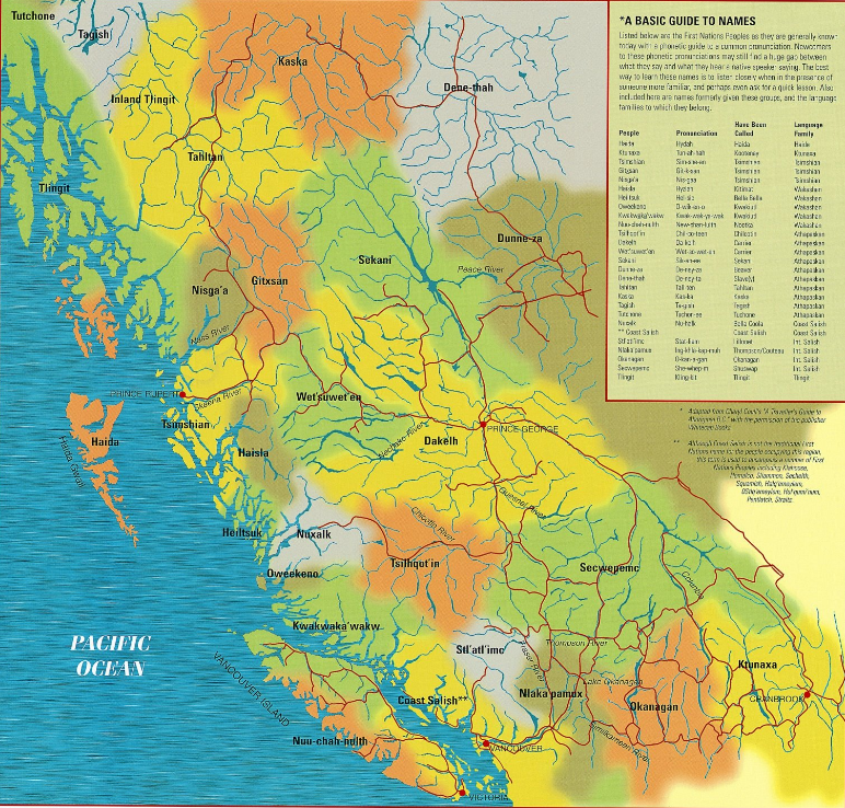
“This map is designed to illustrate the rich diversity of the First Nations Peoples of British Columbia. Like all maps, it is a rendition – a best attempt at reflecting a current reality, recognizing that “the map is not the territory… This map is intended to be an educational tool. Educators and First Nations people are encouraged to work together in interpreting the map, and incorporating new information to it.”
Indeed. In other words, reframe it.
A map is a drawing. It tells a story.
Our stories are open to interpretation, and negotiation.
I find it helpful to remind myself of this. Frequently.

Speak Your Mind